In general, people find the need to use GPS coordinates in rural areas, hiking trails, mountains and parks; where human-readable systems like street addresses and landmarks do not exist and cannot be used to point the location of places.
Since, GPS coordinates (Latitude and Longitude) can pinpoint the exact location of a place with absolute mathematical precision; they are widely used in construction, landscaping, mining, drilling, land/road surveys, fleet management and search/rescue missions.
Find GPS Coordinates Using Phone & Computer
Luckily, most of us do not have to worry about manually finding the GPS Coordinates of any place, as this task is being continuously performed in background by our mobile devices.
For example, both iPhone and Android phone track user location, in order provide driving directions, weather reports and Geotag photos. Similarly, computers can make use of IP Address and Wi-Fi Networks to determine their approximate location.
Since, Location Tracking technology is available on most gadgets, it is really easy to find the GPS Coordinates of your current Location or any other Location by using iPhone, Android phone, Mac or Windows computer.
1. Find GPS Coordinates Using iPhone
In order to find GPS Coordinates using iPhone, you need to enable the “Location Services” feature on your device and allow the Compass App to access your Location Data.
1. Go to Settings > Privacy & Security > Location services.
2. On the next screen, make sure Location Services slider is set to ON Position.
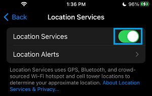
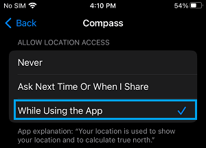
3. On the same screen, scroll down and tap on Compass > on the next screen, select While Using the App option.
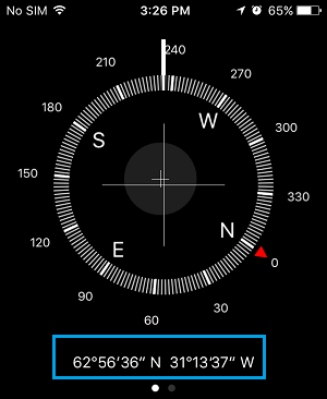
After this, when you open the Compass App on your iPhone, you will find it displaying the GPS Coordinates of your current location at bottom of the screen.
2. Find GPS Coordinates Using Android Phone
If you are using Android Phone, you can find the GPS Coordinates of any location by using Google Maps App.
1. Open Google Maps on your Android Phone.
2. Once you are in Google Maps, tap (or tap and hold) on the Location for which you want to find GPS Coordinates, until you see a red pin.
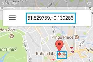
Once the Red Pin appears, you should be able to see the GPS Coordinates of this Location in the search box.
Note: This feature of Google Maps does not work iPhone. While iPhone allows users to input GPS coordinates into Google Maps, it prevents Google Maps from displaying GPS Coordinates.
3. Find GPS Coordinates Using Mac or PC
You can find the GPS Coordinates of any place on Mac or Windows computer by using the web version of Google Maps.
1. On your PC or Mac go to maps.google.com.
2. In the Search bar enter the Address of the place. You will see Google Maps coming up with a Map of the Area, along with its address and street view shot of the place.
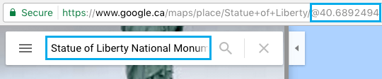
Now, if you take a look at the Address bar in above image, you can see the GPS Coordinates of this place at the end of the URL.
Another way of doing this is to right-click at the place in Google Maps and select What’s here? option in the menu that appears.
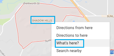
Google Maps will come up with the GPS Coordinates of the selected location.

You can find GPS Coordinates using any of the above methods, that you find convenient and easy to use.
What Are GPS Coordinates
The GPS coordinates of a place are expressed in the form of alphanumeric characters precisely indicating the geographic location of that place in terms of Latitudes and Longitudes.
For example, the GPS coordinates of Statue of Liberty are indicated as 40° 41′ 21″ N 74° 2′ 40″ W (or more accurately as 40° 41′ 21.296″ N 74° 2′ 40.2″ W).
The first set of numbers (40° 41′ 21″ N) provide the Latitude information, indicating that Statue of Liberty is located 40 degrees, 41 minutes and 21 seconds to the north of the Equator and the second set of numbers (74° 2′ 40″ W) provide the Longitude information, indicating that Statue of Liberty is located 74 degrees, 2 minutes and 40 seconds to the west of the Prime Meridian.
In order to understand this better, you need to clearly understand the following terms.
- Latitudes: Are measured North or South of the Equator and vary from 0 degrees at the Equator to +90 degrees at the North Pole and -90 degrees at the South Pole.
- Longitudes: Are measured East or West of Prime Meridian and vary from 0 degrees at Greenwich to +180 degrees East and -180 West (See image below)
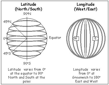
- Equator: Can be defined as an imaginary line going around the earth, half way between North and South Pole.
- Prime Meridian: Can be defined as an imaginary line running from North to South of the Earth through Greenwich in England, United Kingdom.
Prime Meridian divides the Earth into Eastern and Western hemispheres – just like Equator divides the Earth into Northern and Southern hemispheres.
Interesting Info: One degree of Latitude covers about 69 miles or 111 Kilometers.